 |
||||
Map Your Records
Use this simple interface to map your records onto Google Earth.
(Supports UK Ordnance Survey grid references only)
Need help? There is comprehensive documentation HERE
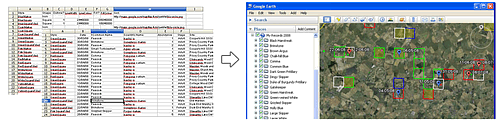
| Example Records File | A set of example records using a range of drawing styles. (A plain text file of tab-separated data).
Right-click over the link and do Save Link/Target As... to save to your computer. | |||||||||||||||||||||
| Example Styles File | A set of drawing styles used by the example records. (A plain text file of tab-separated data).
Right-click over the link and do Save Link/Target As... to save to your computer. This file contains a good set of pre-defined styles to use with your real data:
| |||||||||||||||||||||
| Example Output File | A Google Earth (.kmz) file showing a range of records drawn with different styles.
If clicking on the link doesn't open it in Google Earth then associate .kmz files with Google Earth (Windows Explorer->Tools->Folder Options->File Types). | |||||||||||||||||||||
| If you just want to add columns of latitude and longitude to your records try THIS. |